Saturday, August 18, 2012

Backroads of Oregon II - Day 10

Monday, August 13, 2012 - I have a great view from my room window of several snow-capped peaks: Mt. Bachelor, Three Sisters and Mt. Jefferson.  The haze was caused by the forest fires.

After a buffet breakfast at the Quality Inn in Bend I packed the car and headed for Vancouver, Washington.  I found three caches: one Earthcache and two Traditional Caches this morning.  I found caches on DELORME pages 43 and 37.  I was no longer in the mood for caching.  I was tired and just wanted to get home.  I tried to find a cache this afternoon near Mt. Hood but it was a DNF.

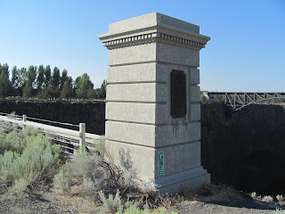
I stopped at Peter Skene Ogden Park to get some photographs and do an Earthcache.  It was already very hot by midmorning.

Marker Text: This park is named for Peter Skene Ogden, 1793-1854. In the fall of 1825, Ogden led a Hudson’s Bay Company trapping party on the first recorded journey into central Oregon, crossing the country to the north and east into the Crooked River valley not far above here. He was in the vicinity again in 1826 bound for the Harney Basin and the Klamath region where he discovered Mount Shasta. Ogden was an important figure in the early fur trade and ranged over all the west. He rescued the survivors of the Whitman Massacre.


Located on Hwy 26 amid the high desert bluffs of Warm Springs, Indian Head Casino beaconed me to check it out and perhaps try my luck at one of the 500 slot machines.  I join the Players Club and was given $5.00 to play.  I could not figure out how to do it or if I wanted to do it.  I got a free tall cup of hot chocolate.  Time to hit the road again!
I stopped at Laurel Hill to take a few photos of Mt. Hood.

I had a delicious Afternoon Tea at Chariteas in Sandy, Oregon.  I sat at my favorite table by the window.
It was good to get back home and be able to sleep in my own bed. Altogether I found 11 Virtuals, four Earthcaches, seven Benchmarks, and 31 Caches.

Backroads of Oregon II - Day 9

Sunday, August 12, 2012 - I found two Virtuals and nine Traditional Caches today and no DNFs.  I found caches on DELORME Atlas pages 70, 71, 64, 84 and 85.  At the first cache - the Stukel Ranch marker - I was attacked by hundreds of hungry mosquitoes.
The Lost River Gap and Ford was a very interesting site.  The Text Marker read: Used by Indians; by Hudson's Bay trappers; by covered wagons; by Fremont 1846; by railroad survey party 1855; by soldiers at Fort Klamath. Site of the Modoc Indian conference in hope of averting war with that tribe; of the first water wheel; of the first fish cannery in the Klamath Country; of stage stops and of roads.

I encountered dense smoke as I drove toward Lakeview.  The smoke came from the Barry Point fire straddling the Oregon-California border where it is burning timber and sagebrush on the Modoc National Forest.  The fire is one of four major blazes still burning across Oregon since a series of lightning storms last week. The weather remained hot and dry.

Lakeview is the "Tallest town in Oregon," standing at 4,800 feet.  There was a fire staging area at the Fairground in Lakeview.

I did a series of "breadcrumb" caches on the way east.  I took a couple photos in Adel and then backtracked on Hwy 140 to just north of Lakeview where I headed northwest to La Pine on Hwy 31.


I stopped at Chandler State Wayside,  a state park 16 miles north of Lakeview.  Somewhat unusual for this part of Oregon, it is covered in large Ponderosa Pine.  The picnic area is near Crooked Creek.  The wayside offers an excellent view of Albert Rim which is approximately two miles to the east of the wayside.  I missed seeing the view probably because of the heavy smoke from the forest fires.

Marker Text: Having been among the early pioneers in this area S.B. Chandler became one of the largest land owners in the vicinity during that era (1870 - 1930). He ran large amounts of sheep and also some cattle.  This property was donated to the Oregon State Highway Department for use as a park in July 1929 by S.B. and Mattie Chandler [and named in their honor].
Big mistake not to fill up the car with gas in Lakeview.  Gas station are evidently not open on Sunday in the heartland.  I stopped at Paisley with a quarter tank of gas and many miles to go.  Paisley is a small town located along Oregon Route 31, between Summer Lake and Lake Abert. The population was 247 at the 2000 census.  I had lunch at the Pioneer Saloon at Paisley.  I ordered a BBQ sandwich with fries and got tater tots!  The two-pump Chewacan (which means little potato) Garage was luckily open so I got $20.00 of gas.
I stopped at Silver Lake Cemetery.  A large monument in the cemetery is a grim reminder of one  of the worst fire disasters in the State of Oregon.  The monument bears the names of 43 persons who lost their lives on Christmas Eve in 1894.   Every family in the area was touched by the tragedy.


I stayed the night at the Quality Inn in Bend. I purchased some items at a nearby Quik Mart for "dinner" which I ate in my room, watching television. 

Friday, August 17, 2012

Backroads of Oregon II - Day 8

Saturday, August 11, 2012 - I packed up the car and reluctantly left the Lake Selmac Resort and the scenic lake.


I headed west to Hwy 199 and the north.  After much searching I found the cache (GC15V53) at the Wilderville Post Office.   The Post Office was established in May 1858 in what was then called Slate Creek.  The name was not officially changed to Wilderville Post Office until 1878.  I found another cache ("The Guardian" - GC390GB) about a half mile away.


I found two Virtuals, two Earthcaches, six Traditional Caches, and two DNFs today.  I found caches/virtuals on DELORME pages: 67, 61,  and 69.

I drove a narrow one lane road along the Rogue River to find and photograph the approximately 35 to 38 ft. high and 360 ft. long Gold Ray Dam (1904).  Imagine my surprise to discover the dam had been removed the Summer of 2010.  For the first time in over 100 years the Rogue River runs free from the Cascades to the Pacific Ocean.
I purchased a tender crisp sandwich for late lunch at Burger King in Central Point.  I turned off onto Hwy 66 at Ashland.  I stopped at Tub Springs to complete an Earthcache and a Virtual.  People were stopping to fill up 5 gallon jars and 5 gallon plastic buckets with the cold fresh spring water.  Tub Springs is high in the Siskiyou Mountains at approximately 4280 ft. elevation.
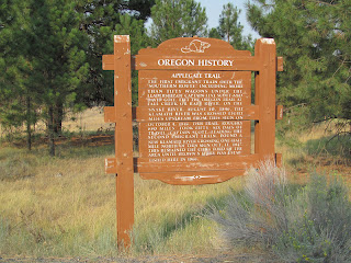
Marker Text: The first emigrant train over the "Southern Route" including more than fifty wagons under the leadership of Captain Levi Scott and David Goff, left the Oregon Trail at Fall Creek or Raft River on the Snake River, August 10, 1846. The Klamath River was crossed eight miles upstream from this sign on October 4, 1846. This trail, roughly 680 miles, took fifty-six days of travel. Captain Scott, leading the second emigrant train, found a new Klamath River crossing one-half mile north of this sign, Oct. 11, 1847. This remained the chief ford of the area until Brown's Ferry was established here in 1868.
I had a good chuckle at the next cache - Open Range (GC1P8DF).   I stayed the night at Klamath Falls at Comfort Inn and Suites.  I ate dinner at nearby Sizzler Restaurant.  The photo is the view from my room. 

Backroads of Oregon II - Day 7

Friday, August 10, 2012 - After a buffet breakfast at Red Lion, I loaded up the car and hit the road.  I found the Virtual: Historic Fish Wrapper (GCC6FF) before leaving town.  Altogether I found five Virtuals, four Traditional Caches and two DNFs today.  I found caches on DELORME p.51, p. 58, p. 65, p. 66, and p. 67.

Somehow I missed visiting two lighthouses: Heceta Head (1894) near Florence and Cape Blanco (1870) at Cape Blanco State Park, a few miles north of Port Orford on Hwy 250.   I should have visited the Hughes House also inside Cape Blanco State Park.
The historic Hughes ranch house is a two-story, 11-room house solidly framed of 2x8 old growth Port Orford cedar. The rectangular structure with cross axial wings, has more than 3,000 square feet, and was constructed in 1898 for $3,800.

The house is open for tours from 10:00 a.m. - 3:30 p.m., except on Mondays, from April 1 to October 31.  A prime example of late Victorian architecture, the Hughes ranch house is listed on the National Register of Historic Places.

Port Orford is the most westerly incorporated city in the contiguous United States.  The Lighthouse on the Cape is the farthermost point west one may drive in the contiguous United States.


Battle Rock was the site of the historic battle between the first landing party of white settlers (Captain Tichenor's crew of nine men) and a local Qua-to-mah band of Athapascan speaking natives.   The event of June 9, 1851 was the beginning of the settling of Port Orford.

Wreck of the Mary D. Hume at Gold Beach, Oregon.


Natural Bridges on the southern Oregon Coast north of Brookings.
The Thomas Creek Bridge is the highest bridge in Oregon.  Its 345 ft. height (higher than the Golden Gate Bridge) spans 970 ft.


The Chetco Community Public Library, in the southern coastal city of Brookings, Oregon, offers over 66,000 items for circulation in their new, spacious facility.  And, more importantly, a restroom.  I tried to find the nearby cache but was unable to do so.  I purchased a Baja Pork Sandwich at Subway in Brookings which I ate by the largest Cypress tree found in Oregon.
I drove through the Jedediah Smith Redwoods State Park.  Lacking good deep harbors, the redwood coast drew little attention until fur trapper Jedediah Strong Smith arrived overland in 1828.  Smith explored the redwood coast for a better route between the Rockies and Pacific.


I drove Hwy 101 south into California and then northeast on Hwy 199 to Selma, Oregon.  I stayed the night in a trailer at Lake Selmac Resort about 10 miles north of Cave Junction on US-199 N/Redwood Hwy.  Bedding and towels were provided.  I ate a couple tacos with a side of salsa and a side of sour cream at a cafe in Selma.